Human activities, climate change, and transitions with regards to energy, food, and nature are leading to changes in the North Sea ecosystem. A healthy and resilient North Sea is of importance to all of us. To safeguard the ecological carrying capacity of the North Sea, insight into its changing ecosystem is essential. Monitoring is crucial in this respect. With the project Digital transformation of Ecological Monitoring (DEM), the Dutch government aims to make ecological monitoring more effective, sustainable, and easier to implement. This initiative is future-oriented and complements ongoing research and monitoring programmes.
Knowledge gap
Project DEM supports the (statutory) tasks of Rijkswaterstaat in reporting on the ecological status of the North Sea. The collected and processed data will support research and monitoring within the Monitoring and Research Programme for Nature Enhancement and Species Protection (MONS) and the Offshore Wind Ecological Programme (Wozep). In addition, the data will support Marine Strategy Framework Directive (MSFD) reports.
Project objectives
The aim of Project DEM is to innovate and digitalise ecological monitoring in the North Sea.
To achieve this, Project DEM will:
- Develop monitoring buoys equipped with a wide range of sensors to generate a continuous time series of multiparameter measurements in the water column at four monitoring sites.
- Develop a Data Management System (DMS) to process collected data autonomously and to monitor data quality, so that raw data can be made available as quickly as possible for ecosystem analyses and model validations.
- Establish an expert group to provide scientific support with the development of the monitoring buoys and the DMS.
- Innovate bird and marine mammal monitoring using image recognition through artificial intelligence.
- Invest in innovative techniques for ecological monitoring at sea.
Rijkswaterstaat (RWS) Central Information Services (CIV) under the programme Information Services at Sea (IV op Zee), commissioned by the Ministry of Agriculture, Fisheries, Food Security and Nature (LVVN).
Project planning
Project planning DEM
12/2023 Approved project mandate, assignment from LVVN to RWS: project in preparatory phase.
09/2024 Finalisation of requirements, monitoring methods, and project approach: project enters implementation phase.
10/2024 – 2025 Preparation and execution of European tender procedures,award and commissioning.
2026 Construction and commissioning of offshore monitoring buoys, commencement of research projects.
2027 – 2028 offshore monitoring and completion of research projects.
DEM within Jerico 2025-2037
Monitoring buoys
ADCP: Acoustic Doppler Current Profiler. cDOM: coloured Dissolved Organic Matter. Chl-A: Chlorophyl A. CTD: Conductivity Temperature Depth. DO: Dissolved Oxygen. FCM: Flow Cytometry. Fish tag receiver for the European Tracking Network. HSR: HyperSpectral Radiometer. LDPSA: Laser Diffraction Particle Size Analyser. Motus Wildlife Tracking System. PAM: Passive Acoustic Monitor hydrophone. PAR: Photosynthetically Active Radiation. STAF: Single Turnover Active Fluorometry. TUR: Turbidity.
Pairs of monitoring buoys will be deployed at four monitoring station in the Dutch North Sea. These buoys will generate continuous time series of multiparameter measurements. Each pair consists of a string buoy and an ecology buoy.
String buoy
A smaller buoy with sensors positioned at different depths. The string buoy measures parameters that provide insight into primary production and stratification (Chl-A, cDOM, CTD, DO, hyperspectral light, PAR, turbidity). In addition, underwater sound will be recorded using a Passive Acoustic Monitor (PAM) hydrophone, and fish tags will be received via a fish tag receiver.
Ecology buoy
A larger buoy with more electrical power and advanced sensors near the water surface. The ecology buoy measures abiotic factors (ADCP, Chl-A, cDOM, CTD, DO, LDPSA, turbidity). Primary production and the plankton community are also examined in detail using STAF and flow cytometry (FCM).
In addition, a simple weather station will be installed above the water, incident light (PAR) will be measured, and bird and bat tags will be received using a Motus Wildlife Tracking System.
Monitoring stations
Locations of DEM monitoring stations in the North Sea
Noordwijk (10 km offshore, 20 m depth): Rhine plume, historical dataset from CEFAS monitoring buoy.
Walcheren (20 km offshore, 20 m depth): Borssele wind farm.
German Bight (35 km offshore, 20 m depth): Oyster reef restoration.
Terschelling (135 km offshore, 48 m depth): Oyster grounds, wind energy search area, low oxygen concentrations near the bottom, ships equipped with FerryBoxes pass through, historical dataset from CEFAS monitoring buoy.
Data management
Data management within DEM
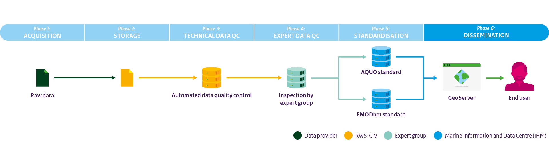
For the vast amount of data to be collected, an automated Data Management System (DMS) is being designed. Data will be made accessible in line with the FAIR principles (Findable, Accessible, Interoperable, and Reusable).
This will be achieved by testing data quality, adding metadata, and comply with national (AQUO) and international (SeaDataNet / EMODnet) data standards.
To convert raw data into usable data for ecosystem analyses and model validations, six phases are defined:
- Acquisition,
- Storage,
- Technical data quality control,
- Expert data quality control,
- Standardisation,
- Dissemination.
Scientific support from expert group
From left to right: Mainah Folkers (RWS), Laura Dinkla (RWS/Aqitec), Ivo Wieling (RWS/Aqitec), Kees Borst (RWS), Sarah Rautenbach (Deltares), Anouk Blauw (Deltares), Arthur de Waard (RWS), Nicole Dijkman (RWS), Joris Diehl (RWS), Erik Hendriks (Deltares). Attending online: Jef Huisman (UvA) and Dick van Oevelen (NIOZ).
Project DEM has initiated an expert group to provide scientific support for the development of the monitoring buoys and the data management system. The expert group is a collaboration between Rijkswaterstaat (RWS) and research institutes, initially Deltares, the Royal Netherlands Institute for Sea Research (NIOZ), and the University of Amsterdam (UvA) have joined.
The group has expertise in the biological, chemical, and physical climate of the North Sea. In addition, the experts have spezialised knowledge of the operation and deployment of specific sensors.
The expert group will advise on:
- Placement and settings of sensors on the monitoring buoys.
- Sensor calibration and sensor validation.
- Data quality control and validation.
- Qunatifying primary production in carbon units.
- Estimating chlorophyl-A concentration from fluorescence measurements with less frequent in situ water samples.
- Deriving phytoplankton biovolume from imaging flow cytometer data.
- Compliancy with the Joint European Research Infrastructure for Coastal Observations (JERICO-RI).
Bird and marine mammal monitoring using artificial intelligence
Currently, birds and marine mammals above the North Sea are monitored by human observations from aircraft as part of the Dutch national long term monitoring called Monitoring Waterstaatkundige Toestand des Lands (MWTL). However, due to the construction of wind farms, the flying altitude above the North Sea will be raised, making human observations increasingly challenging. Therefore, project DEM is investing in the development of a model that can autonomously identify and annotate birds.
Detected and identified common scoters
This investment focuses on improving a model developed in the project Artificial Intelligence for recognising megafauna (seabirds and mammals) in and around offshore wind farms (AI-MEG) of Wageningen Marine Research (WMR). This will enable more bird species to be identified with greater reliability.
An additional focus will be placed on protected bird species such as the common guillemot. For this purpose, more aerial video footage will be collected covering the North Sea, with a finer grid in the coastal zone, in Natura2000 areas, and in wind energy search areas. Flights will be carried out in parallel wherever possible to compare human observations with automated image recognition, thereby preventing a trend break in bird monitoring. Ultimately, consideration will be given to how the new bird monitoring method can be implemented within MWTL at Rijkswaterstaat.
Investing in innovative techniques for water quality analysis and ecosystem monitoring
One of DEM’s subprojects is OTTER (Development and Testing of Technology for the Rijkswaterstaat Ecology Buoy). The OTTER subproject aims to develop innovative methods for water quality analysis and ecosystem monitoring. For this subproject, DEM intends to collaborate with NIOZ.
The focus will be on:
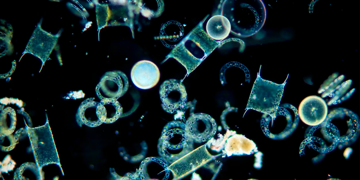
- Plankton imaging: advanced image recognition for the identification and quantification of plankton populations.
- Vertical profiling: using sensors for water quality measurements in the water column.
- Smart maintenance: intelligent maintenance systems for more efficient and sustainable management of sensors.
These technologies will be developed for broad applicability and a high technology readiness level (TRL). Project DEM will make a material contribution by making a test buoy available for research. This should enable future implementation within Rijkswaterstaat and contribute to more accurate and efficient ecological monitoring.